-
TrackoBit
Manage commercial vehicles with the new-age Fleet Management Software
TrackoBit -
TrackoField
Streamline your scattered workforce with Field Force Management Software
TrackoField -
Features Resources
-
Blog
Carefully curated articles to update you on industrial trends. -
White Paper
Insightful papers and analysis on essential subject matters. -
Glossary
Explore an alphabetical list of relevant industry terms. -
What’s New
Get TrackoBit & TrackoField monthly updates here. -
Case Study
Explore the cases we solved with our diverse solutions. -
Comparisons
Compare platforms, features, and pricing to find your best fit.
-
About Us
Get to know TrackoBit: our team, ethos, values, and vision. -
Careers
Join the most dynamic cult of coders, creatives and changemakers. -
Tech Support
Learn about our technical support team and services in detail. -
Events
Check out the exhibitions where we left our marks and conquered. -
Contact Us
Connect with us and let us know how we can be of service.
GPS vs NavIC: Global Reach vs. Regional Precision
- Author:Anvesha Pandey
- Read Time:9 min
- Published:
- Last Update: August 30, 2024
Table of Contents
Toggle
Want to know what’s better, GPS or NavIC? This piece of writing will surely give you clarity on all the ins and outs of both navigation systems.
Table of Contents
Toggle
No doubt that the Global Positioning System is reliable for pinpointing locations with incredible accuracy. But to avoid heavy reliance on GPS technology, ISRO decided to bring our country’s very own navigation system called “NavIC”. That was a real proud moment for the country.
GPS and NavIC both are satellite-based navigation systems that offer you location and time information. But where GPS provides you with global coverage, NavIC on the other side is designed mainly for the Indian subcontinent.
Well, that’s not it. These two navigation systems have more contrasting features, you didn’t know of. Here is a quick comparison between GPS vs NavIC.
Before that, let’s know about both technologies individually with respective histories.
What is NavIC?
NavIC (Navigation with Indian Constellation) is an autonomous satellite navigation system developed by ISRO (Indian Space Research Organisation). The system provides users with accurate position information services in India and the surrounding region, extending up to 1,500km from its borders.
NavIC consists of a constellation of seven satellites and a network of ground stations, offering two levels of services-
- Standard Positioning Services (SPS) – for civilian use.
- Restricted Service (RS) – for the authorized users.
IRNSS aka NavIC aims to provide position accuracy better than 20 meters in the primary service area, enhancing India’s navigation capabilities and independence.
Discover the insights of NavIC- What is NavIC- India’s Homegrown GNSS System
What is GPS?
The GPS (Global Positioning System) is a satellite-based navigation system developed and maintained by the United States Department of Defense. It consists of a constellation of at least 24 satellites (extendable up to 31 satellites) orbiting Earth, providing geolocation and time information to the GPS receivers.
GPS is widely used worldwide in civilian, commercial, and military operations, providing position accuracy within a few meters.
Now that we have a clear picture of these two technologies, let’s have a sneak peek into the history of these two navigation technologies.
Discover GPS in detail- What is GPS and How Does GPS Work?
The History of GPS vs the History of Navic
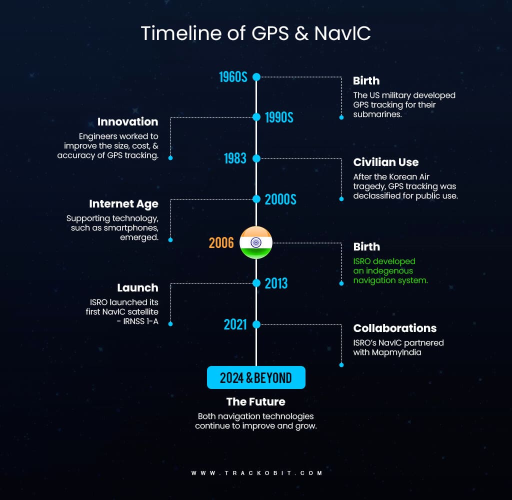
Timeline of GPS & NavIC
GPS has been a Global pioneer for decades whereas NavIC has been an emerging Indigenous technology in recent times. While both of these navigation systems serve the fundamental purpose of determining locations, their histories, development, and capabilities exhibit different characteristics.
Timeline of GPS
1973– The U.S. Department of Defense initiated the GPS project to enhance military navigation and timing capabilities.
1978- In this year, the launch of the first experimental Block-1 GPS satellite took place, which led to the beginning of the formation of the GPS satellite constellation.
1983– Following a tragic navigation error involving Korean Air Lines Flight 007, GPS started becoming available for civilian use to improve global aviation safety.
1989– Then the deployment of the first Block-II satellite took place, transitioning GPS from experimental to operational status.
1993– The GPS constellation reached full operational capability with 24 satellites, providing worldwide coverage.
2000– The U.S. government disabled Selective Availability, significantly improving civilian GPS accuracy to within approximately 20 meters.
2010- The introduction of new civilian signals (L2C and L5) as part of GPS modernization efforts took place, enhancing accuracy and reliability.
2018- The launch of the first GPS III satellite took place, offering advanced capabilities such as improved accuracy, enhanced anti-jamming, and a longer lifespan.
2023– Ongoing advancements and updates maintain GPS as a cornerstone of global navigation, supporting diverse applications across civilian, commercial, and military domains.
Timeline of NavIC
2006- The Indian government approved the Indian Regional Navigation Satellite System (IRNSS) project, later named NavIC, to develop an independent regional navigation system.
2013- Launch of the first NavIC satellite, IRNSS-1A, marking the beginning of India’s efforts to establish a homegrown navigation system.
2016- Completion of the NavIC constellation with the launch of IRNSS-1G, providing initial operational capability.
2017- NavIC became operational, offering Standard Positioning Service (SPS) for civilian users and Restricted Service (RS) for authorized users, with position accuracy better than 20 meters in its primary service area.
2018- The Indian government announces the integration of NavIC in mobile devices to promote widespread adoption and usage.
2020- Collaboration between ISRO and Qualcomm led to NavIC support in Snapdragon chipsets, resulting in its incorporation in various smartphone models.
2021- Collaboration of ISRO’s NavIC with MapmyIndia enhanced Indigenous mapping solutions, providing highly accurate and reliable navigation especially made for India’s use.
2022- Expansion of NavIC services with the launch of additional satellites and ground stations, enhancing coverage and accuracy.
2023– Continuous improvements and the addition of new satellites ensure NavIC remains a robust and reliable regional navigation system, supporting diverse applications in India and neighboring areas.
GPS vs NavIC- A Table Highlighting All the Major Differences
| Parameters | GPS (Global Positioning System) | NavIC (Navigation with Indian Constellation) |
| Development Origin | GPS technology was developed by the U.S. Department of Defense. | The NavIC technology was developed by the Indian Space Research Organisation (ISRO). |
| Coverage Area | Global coverage, accessible anywhere in the world. | Primarily covers India and extends up to 1,500 km beyond its borders. |
| Number of Satellites | Typically consists of 31 operational satellites. | Comprises a constellation of 7 active satellites. |
| Accuracy | Approximate accuracy of 20 meters for public use. | Better accuracy, typically between 5 to 10 meters for civilian use, and up to 0.5 meters for military applications. |
| Frequency Bands | Primarily operates on the L1 (1575.42 MHz) and L2 (1227.60 MHz) band. | Uses L5 (1176.45 MHz) and S-band (2492.028 MHz) for improved accuracy and reduced interference. |
| Services Offered | Offers civilian and military services, with military access to more precise data. | Provides Standard Positioning Service (SPS) for civilians and Restricted Service (RS) for authorized users. |
Use Cases of GPS and NavIC
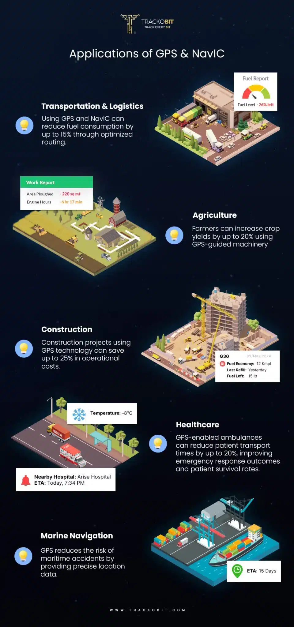
Applications of GPS and NavIC
GPS technology plays a vital role in various sectors such as agriculture, logistics, transportation, emergency services, and public safety. In agriculture, GPS technology supports precision farming when integrated with various sensors, enhancing productivity and resource management.
The logistics and transportation sectors benefit significantly from GPS by optimizing routes for delivery vehicles, tracking shipments in real-time, and managing fleet operations efficiently. This efficiently helps reduce costs and improve service levels.
Additionally, when we talk about emergency services GPS facilitates prompt responses by enabling rescue teams to quickly locate distressed individuals. This further aids in search and rescue operations during disasters. To add more uses of the technology in disaster relief helps coordinate efforts more effectively by providing real-time location data of required services and resources.
Now, let’s unfold the use case where NavIC fits!
NavIC, India’s regional navigation satellite system, focuses on applications particularly relevant to India and its neighboring regions. It is widely used for public vehicle tracking, improving safety standards in commercial transportation, and ensuring real-time alerts for emergencies, such as alerts for fishermen in distress at sea.
The technology is also used in disaster management efforts as it provides precise location data, which is crucial for assessing damage, coordinating rescue operations, and streamlining disaster response initiatives.
NavIC contributes to agriculture through applications that provide farmers with accurate location information for effective monitoring and management of agricultural activities.
Additionally, the system finds applications in various national projects like public vehicle safety and real-time information systems, highlighting its role in enhancing transport safety and efficiency.
Comparing the Applications of GPS and NavIC
While both GPS and NavIC are essential for navigation at their parts, their applications differ significantly based on their respective coverage areas and target uses. GPS offers a global solution, supporting applications in diverse fields like international shipping, global logistics, and global travel.
On the other hand, NavIC is specially designed for regional applications within India, focusing on domestic needs, such as public safety and disaster management, which aligns with India’s strategic objectives.
The integration of these systems into smartphones and other devices enhances their accessibility and promotes safety measures, where GPS aids globally, while NavIC fulfills specific regional requirements, showcasing their complementary roles in navigation technology.
| 📌Running a fleet in agriculture, healthcare, or FMCG?
With TrackoBit’s advanced fleet management systems, optimize operations, reduce costs, and enhance efficiency. By leveraging cutting-edge telematics and data analytics, we provide real-time visibility, predictive insights, and actionable intelligence to streamline your fleet operations. Ready to manage your fleet with us? |
What are the Compliances of Owning a GNSS System?
Well, owning and operating a Global Navigation Satellite System requires compliance with various international regulations, standards, and agreements to ensure safety, compatibility, and interoperability.
Some of these compliances are mentioned below-
1. International Regulation & Treaties
For owning a GNSS system, countries must comply with international regulations and treaties. This involves aligning with agreements that promote interoperability and compatibility among various navigation systems. Also, the countries must adhere to the established frameworks set by the organizations like the International Committee on Global Navigation Satellite Systems (ICG).
2. Spectrum Management and Frequency Allocation
Countries are also required to manage their electromagnetic spectrum allocation in line with international agreements to ensure the effective operation of GNSS systems. This involves designating specific frequency bands, like for NavIC, we have L5 & S5 whereas for GPS we have L1& L2 for GNSS usage. Coordination with national and international authorities is required to prevent harmful interference that could disrupt navigation services.
3. Technical Standards and Operational Requirements
Compliance with recognized technical standards is critical for the successful deployment and operation of GNSS systems. This includes the following recommended practices for differential GNSS services, performance standards, and requirements tailored for diverse applications such as aviation, surveying, and maritime navigation.
4. Security and Safety Regulations
National governments must implement security measures to protect GNSS systems from cyber threats, such as spoofing and jamming. Regulations should establish robust signal authentication mechanisms, resilient receiver designs, and real-time monitoring systems to detect anomalies and ensure operational continuity under various threat scenarios.
5. Justification of Costs and National Interests
Countries must justify the financial investments associated with creating and maintaining a GNSS system based on genuine security needs and coverage objectives. This involves assessing realistic requirements that the GNSS system is expected to address, thus ensuring that expenditures align with national interests and strategic goals.
All in all, by adhering to these compliances and regulations, any country can develop its own GNSS system and successfully operate it.
Parting Words
It’s been a long journey! In previously written pieces, we unfolded the basics of GPS, then NavIC, and now here we are at this much-needed comparison between the two. It’s clear how both of these navigation systems are equally important, and contributive at their level. NavIC came into play to not outshine GPS but to ensure people in India receive consistent and accurate positioning and timing data.
While GPS and NavIC differ in their origins and coverage areas, both systems have undeniably transformed the way we perceive and interact with the world. As technology continues to evolve, it is exciting to see a future where these systems collaborate, offering unparalleled precision and reliability, propelling us into amazing navigation.
TrackoBit applauds and supports such innovative moves. We will continue to offer more precise and accurate locational and timing data to fleet operating businesses.
Let’s partner up for a great synergy!
FAQs on the Difference Between GPS vs NavIC
-
What is NavIC?
NavIC, or Navigation with Indian Constellation, is an autonomous satellite navigation system developed by the Indian Space Research Organisation (ISRO). It provides accurate position information services to users in India and the surrounding region. NavIC is designed to offer better accuracy in this specific geographical area compared to other global navigation systems.
-
Which is better, GPS or NavIC?
GPS and NavIC both are some of the great technological advancements in their own places. But when it comes to accuracy, NavIC claims to reach up to 5-10 meters of the designated area, whereas GPS is only confined to having an accuracy of 20 meters. Apart from the accuracy part, NavIC also possesses a faster latch-on time aka Time To First Fix (TTFF).
-
What is GPS?
The Global Positioning System (GPS) is a satellite-based navigation system developed and maintained by the United States Department of Defense. It consists of a network of at least 24 satellites orbiting the Earth. It provides geolocation and time information to GPS receivers anywhere on or near the Earth where there is an unobstructed line of sight to four or more GPS satellites.
Anvesha is a communication specialist at TrackoBit. With a strong background in media and communications, she adds much-needed balance and brevity to TrackoBit’s... Read More
Related Blogs
-

Why is Driver Drowsiness Detection System Important for Fleet Management?
Shemanti Ghosh February 4, 2026A driver drowsiness detection system is critical for fleet management. It helps prevent fatigue-related accidents and reduces operational risks through…
-
When Tracking Needs a Clock: Rethinking Fleet Visibility
Tithi Agarwal December 24, 2025Read on to understand why fleet tracking works better when it follows working hours. Because visibility should support operations, not…
-

What Makes TrackoBit’s Video Telematics Software Truly Next-Gen?
Shemanti Ghosh December 17, 2025TrackoBit’s video telematics software blends smart video intelligence with full server control. The result? Superior fleet reliability and safety.
-
Plug, Pair, Perform TrackoBit Introduces BLE Sensor Integration
Tithi Agarwal November 26, 2025TrackoBit’s BLE Sensor Integration enables wireless, real-time monitoring with faster installs and accurate insights. It improves fleet efficiency, visibility, and…

Subscribe for weekly tips to optimize your fleet’s potential!
Your inbox awaits a welcome email. Stay tuned for the latest blog updates & expert insights.
"While you're here, dive into some more reads or grab quick bites from our social platforms!"Stay Updated on tech, telematics and mobility. Don't miss out on the latest in the industry.
We use cookies to enhance and personalize your browsing experience. By continuing to use our website, you agree to our Privacy Policy.


